
TL;DR:
- Wildlife corridors and fencing should be designed as interconnected systems to promote species movement and ecosystem resilience. Targeted fence removal and innovative virtual fencing can significantly enhance habitat connectivity while managing livestock and reducing costs. Strategic planning, species-specific designs, and stakeholder collaboration are essential for successful conservation and land-use outcomes.
Wildlife corridors and fencing are spatial and structural tools engineered to maintain or restore connectivity between fragmented habitats, supporting species movement, genetic exchange, and ecosystem resilience. When designed correctly, fencing does not simply exclude wildlife. It directs, protects, and channels animal movement in ways that serve both conservation and agricultural goals. Recent research from the Greater Masai Mara and the Washington State I-90 project confirms that the relationship between wildlife corridors and fencing is one of the most consequential decisions a land manager makes. Getting it right requires species-specific thinking, evidence-based design, and a willingness to rethink where fences belong at all.
What are the key types and designs of wildlife corridors and fencing?
Wildlife corridor design is not a single solution. No one-size-fits-all typology exists, and selecting the wrong type for a given species or landscape can waste resources and fragment habitat further. The four most widely applied typologies are riparian buffers, hedgerow networks, overpass crossing structures, and underpass tunnels. Each serves a distinct ecological function and demands a different fencing strategy.
Riparian buffers follow waterways and provide linear movement paths for species that track moisture gradients. The Mesoamerican Biological Corridor applied this approach with measurable success: by integrating riparian buffers into its design, planners reduced land acquisition costs by 35% compared to purchasing new corridor land. That figure matters to any land manager working with a fixed budget.
Crossing structures, including overpasses and underpasses, are the most engineered solution in the toolkit. The Washington State I-90 project combined 50-meter-wide overpasses with 200-meter vegetated ramps, and the result was a 78% reduction in wildlife-vehicle collisions. That outcome demonstrates what happens when fencing and crossing structures are treated as a system rather than separate interventions. Fencing that channels animals toward crossings, rather than simply blocking roads, is the difference between a corridor that works and one that does not.
Fencing design standards for wildlife permeability
Fence height, material, and visibility all determine whether a fence is a barrier or a guide. The following standards reflect current best practice for wildlife-friendly fencing in corridor contexts:
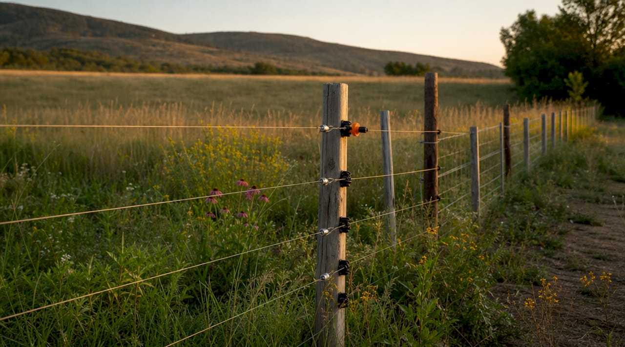
- Height: 40 to 42 inches for most ungulate species. Higher fences block deer and pronghorn movement without adding livestock containment value.
- Bottom wire clearance: Minimum 16 to 18 inches from the ground to allow passage of smaller mammals, including foxes, badgers, and juvenile ungulates.
- Barbed wire: Avoid on the top strand in corridors. Smooth wire or high-tensile wire reduces entanglement mortality.
- Visibility: Adding flagging or wildlife deterrent tape to the top wire reduces collision rates for low-flying birds.
- Materials: Eco-friendly fence materials like bamboo, reclaimed wood, and sustainable composites reduce environmental footprint when properly matched to site conditions.
For underpass tunnels, design details matter at a granular level. Underpasses require natural substrate floors and ambient lighting below 1 lux to promote use by medium and small species. Artificial lighting inside crossing tunnels actively deters many species, which means a well-intentioned underpass can sit unused for years if the lighting specification is wrong.
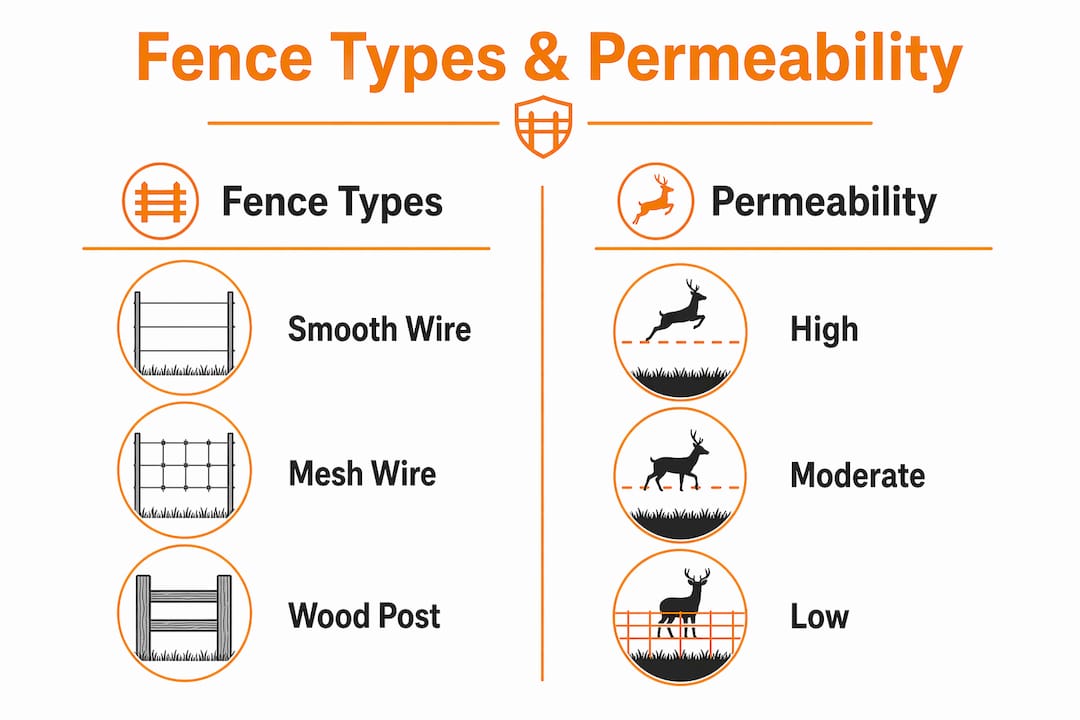
| Fence type | Wildlife permeability | Best corridor application |
|---|---|---|
| Smooth high-tensile wire | High | Ungulate corridors, riparian buffers |
| Barbed wire (top strand) | Low | Avoid in active corridors |
| Woven wire (wildlife spec) | Medium | Predator exclusion with passage gaps |
| Virtual/GPS fence | Very high | Livestock containment near corridors |
| Bamboo or reclaimed wood | Medium to high | Low-pressure zones, hedgerow edges |
Pro Tip: When designing fencing for a corridor project, walk the fence line at dawn and dusk to observe actual animal behavior. GPS collar data and camera traps confirm movement patterns, but direct observation catches fence-jumping, entanglement risk, and bottleneck points that remote data often misses.
How does targeted fence removal improve wildlife connectivity?
Targeted fence removal is one of the highest-return interventions available to land managers working in fragmented landscapes. A 2026 study in the Greater Masai Mara Ecosystem used GPS tracking data to prioritize which fence segments to remove across distances of 15 to 140 kilometers. The result: targeted removal increased connectivity by 39% to 54%. That gain came not from clearing entire fence networks but from removing strategically selected segments. The implication is significant. You do not need a landscape-scale project to achieve landscape-scale results.
The key principle is prioritizing modest, targeted removals over large-scale clearance. Removing the wrong fence in the wrong location can redirect livestock pressure onto unprotected land or create human-wildlife conflict where none previously existed. The Greater Masai Mara study identified that the highest-value removals were segments that sat directly across known migratory routes, not the longest or most visible fence lines.
A common objection to fence removal in mixed-use landscapes is disease transmission risk between wildlife and livestock. The KAZA Transfrontier Conservation Area, covering 520,000 square kilometers across five countries, addressed this directly. A qualitative risk assessment found that fence removal paired with mitigation measures such as skilled herding and vaccination programs poses no significant increase in disease transmission risk. That finding reframes the veterinary fence paradigm that has dominated southern African land management for decades.
The practical steps for a targeted removal program follow a clear sequence:
- Map existing fence networks against GPS movement data for target species to identify which segments block the highest-traffic migratory routes.
- Assess livestock management capacity in the removal zone. Herding skills, vaccination coverage, and grazing rotation plans must be in place before any fence comes down.
- Engage neighboring landowners and communities early. Fence removal on one property affects movement patterns and livestock security on adjacent land.
- Remove incrementally and monitor. Camera traps and GPS collars on focal species confirm whether connectivity gains match predictions within the first two seasons.
- Document and adapt. Publish results, even negative ones. The Greater Masai Mara study’s value came partly from its transparent methodology, which other managers can replicate.
“Modest, targeted fence removals consistently outperform large landscape clearance projects in both cost efficiency and measurable connectivity gain.” — Research synthesis from the Greater Masai Mara GPS tracking study.
What are emerging fencing technologies and their impact on habitat connectivity?
Virtual fencing represents a genuine shift in how land managers think about livestock containment near wildlife corridors. GPS-enabled systems like the Gallagher eShepherd use solar-powered neckbands and app-based boundary control to contain cattle without any permanent physical barrier. Virtual fencing reduces ecological fragmentation compared to traditional wire fences by creating dynamic, adjustable containment zones that can be moved seasonally to align with wildlife movement patterns.
The conservation implications are direct. A permanent wire fence installed to protect a riparian buffer from cattle grazing creates a fixed barrier that also blocks deer, elk, and smaller mammals. A virtual fence boundary achieves the same livestock exclusion while leaving the ground surface fully permeable to wildlife. For land managers balancing agricultural productivity with habitat connectivity solutions, this is a meaningful operational difference.
The ecological footprint comparison between traditional and virtual fencing breaks down across several dimensions:
- Soil disturbance: Post installation for traditional fencing disturbs soil and root systems along the entire fence line. Virtual systems require only base station placement.
- Entanglement risk: Wire fences cause documented mortality in ungulates, birds, and small mammals. Virtual systems eliminate this risk entirely within the contained zone.
- Flexibility: Traditional fences are fixed infrastructure. Virtual boundaries can be redrawn within hours to open seasonal corridors or respond to drought-driven movement shifts.
- Cost over time: Initial hardware investment for virtual systems is higher, but the absence of ongoing wire maintenance and post replacement reduces long-term cost.
For a detailed breakdown of how GPS-enabled systems work in practice, Fencefast’s explanation of virtual fencing for cattle covers the technology and its application in Canadian agricultural contexts.
Pro Tip: When integrating virtual fencing near a corridor, set seasonal boundary adjustments to coincide with known migration windows for your target species. A boundary that contracts in spring to open a riparian buffer costs nothing operationally but can restore months of blocked movement for ungulates.
How to effectively integrate wildlife corridors and fencing in land management
Effective integration of corridor design and fencing decisions requires planning that starts at the landscape scale and resolves to the fence-post level. The following sequence reflects what successful projects share in common.
- Define target species and movement requirements first. A corridor designed for grizzly bears requires fundamentally different dimensions, substrate, and fencing setbacks than one designed for pollinators or amphibians. Species-specific corridor selection is the single most important design decision.
- Align corridor placement with existing natural features. Riparian zones, hedgerow networks, and topographic features like ridgelines already function as movement paths. Building corridors along these features, as the Mesoamerican Biological Corridor demonstrated, cuts costs and increases adoption by neighboring landowners.
- Design fencing as a system, not a boundary. Every fence on a property either directs animals toward a corridor or away from one. Mapping all existing fences against movement data before adding new infrastructure prevents inadvertent barrier creation.
- Build livestock management practices into the corridor plan. Rotational grazing, herding protocols, and vaccination schedules are not separate from corridor management. They are the conditions that make fence removal and wildlife-friendly fencing viable without increasing conflict.
- Establish a monitoring protocol before construction begins. Camera traps, GPS collars on focal species, and annual vegetation surveys provide the baseline data needed to evaluate whether the corridor is functioning. Without pre-project data, post-project success is impossible to measure.
- Engage stakeholders across property boundaries. Corridors that cross multiple land tenures require formal agreements. The KAZA TFCA model, operating across five national jurisdictions, demonstrates that transboundary coordination is achievable when disease risk, livestock security, and economic benefit are addressed transparently.
Fencefast’s practical guide for landowners on creating wildlife corridors covers the Canadian regulatory and land tenure context that shapes corridor planning from British Columbia to Ontario.
Key takeaways
Wildlife corridors and fencing work best when fencing is treated as a directional tool rather than a barrier, and when targeted removal is prioritized over landscape-scale clearance.
| Point | Details |
|---|---|
| Targeted fence removal | Removing strategic segments increases connectivity by 39% to 54% without full fence clearance. |
| Crossing structure design | Overpasses and underpasses must be paired with guiding fences and low-light conditions to drive species use. |
| Virtual fencing advantage | GPS-enabled systems eliminate entanglement risk and allow seasonal corridor openings without infrastructure changes. |
| Species-specific design | No single corridor typology works for all species; target species behavior must drive every design decision. |
| Livestock management integration | Herding and vaccination programs make fence removal viable without increasing disease transmission risk. |
The case for rethinking where fences belong
Most land managers I speak with treat fencing as a fixed cost of doing business. You fence your pastures, you protect your crops, and wildlife works around it. That framing is increasingly difficult to defend given what the research now shows. The Greater Masai Mara GPS study did not find that fences are categorically bad. It found that specific fence segments, in specific locations, are responsible for disproportionate connectivity loss. Remove those segments and you recover more than half the connectivity of an unfenced landscape. Leave them in place and no amount of corridor planting or crossing structure investment compensates.
The shift I find most significant is not the fence removal research. It is the emergence of virtual fencing as a practical livestock management tool. For years, the argument against wildlife-friendly fencing was economic. Farmers and ranchers cannot absorb the cost of redesigning infrastructure to accommodate species movement. Virtual fencing changes that calculation. When your containment boundary is a GPS coordinate rather than a wire strand, you can open a migratory corridor in spring and close it in fall without touching a single post. That is not a theoretical benefit. Fencefast carries Gallagher eShepherd systems and works with Canadian ranchers who are already doing this.
The uncomfortable reality is that most corridor projects fail not because of bad science but because of poor stakeholder alignment and inadequate livestock management planning. The KAZA TFCA assessment is instructive here. Five countries, 520,000 square kilometers, and the conclusion was that disease risk from fence removal is manageable if herding and vaccination are in place. The fences were never the primary disease barrier. They were a substitute for good management. That is worth sitting with.
— Juiced
Fencefast solutions for wildlife-friendly corridor projects
Fencefast carries the full range of products that corridor projects and wildlife-friendly farm management require, from high-tensile smooth wire and wildlife-spec woven fencing to Gallagher eShepherd virtual fencing systems. As an authorized Gallagher dealer with a 26-year partnership, Fencefast provides design consulting, virtual fencing setup guidance, and access to Canadian government funding programs including OFCAF and BMP grants that apply directly to virtual fencing adoption. Whether you are retrofitting an existing fence line to meet wildlife permeability standards or planning a corridor from scratch, Fencefast’s product catalog and expert team support every stage of the project. Visit Fencefast to explore fencing solutions built for both agricultural productivity and conservation outcomes.
FAQ
How do wildlife corridors work?
Wildlife corridors work by providing connected habitat patches that allow animals to move between otherwise isolated areas for feeding, breeding, and seasonal migration. Fencing, crossing structures, and vegetation management are the primary tools used to direct and protect that movement.
What fence height is recommended for wildlife corridors?
A fence height of 40 to 42 inches with a bottom wire clearance of 16 to 18 inches is the current standard for ungulate-permeable fencing in corridor contexts. Barbed wire on the top strand should be replaced with smooth wire to reduce entanglement mortality.
Does removing fences increase disease risk for livestock?
A risk assessment covering the KAZA Transfrontier Conservation Area found that fence removal with mitigation measures poses no significant increase in disease transmission risk when skilled herding and vaccination programs are in place.
What is virtual fencing and how does it support habitat connectivity?
Virtual fencing uses GPS-enabled neckbands and app-controlled boundaries to contain livestock without permanent wire infrastructure. Because it leaves the ground surface physically open, it allows wildlife to move freely through areas that traditional fencing would block.
How much connectivity can targeted fence removal restore?
GPS tracking research in the Greater Masai Mara found that removing selected fence segments increased habitat connectivity by 39% to 54%, with the highest gains coming from segments that directly crossed established migratory routes.

