
TL;DR:
- GPS livestock tracking in Canada reduces cattle escapes and enhances herd management.
- It provides real-time location, behavioral data, and alerts, improving breeding and grazing efficiency.
- Initial costs are high, but long-term labor savings and increased productivity offer strong ROI.
Canadian ranchers are discovering that a single GPS collar can eliminate months of searching for stray cattle, with some operations reporting zero escapes after fitting their herds with tracking technology compared to frequent, costly incidents before. GPS livestock tracking has moved well beyond a novelty gadget stage and is now reshaping how producers across the prairies, boreal fringe, and remote range land manage their animals every single day. This article breaks down how the technology works in real Canadian conditions, what the numbers look like for operations of different sizes, and the practical steps you need to take to adopt it without wasting money or time.
Table of Contents
- How GPS livestock tracking works in Canada
- Benefits of GPS tracking for Canadian ranchers
- Financial considerations: Costs, ROI, and scalability
- Key challenges and practical adoption tips
- A fresh perspective: Why GPS tracking is more than a high-tech add-on
- Ready to get started with GPS livestock tracking?
- Frequently asked questions
Key Takeaways
| Point | Details |
|---|---|
| Real-time herd visibility | GPS tags let you see where your animals are and act fast on escapes or issues. |
| Labor and cost savings | Significant reductions in labor and losses help offset the initial tech investment over time. |
| Proven results in Canada | Canadian trials show better breeding outcomes and near-elimination of escapes using GPS tracking. |
| Cold-ready but not foolproof | Systems work in Canadian winters, but battery and signal challenges require planning. |
How GPS livestock tracking works in Canada
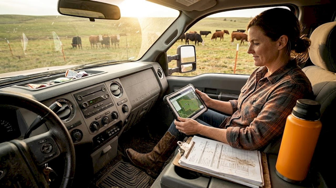
At its core, GPS livestock tracking relies on a tag or collar fitted to each animal that communicates its location to a central platform, usually through a cellular or satellite network. The tag records coordinates at set intervals, anywhere from every few minutes to once per hour, and pushes that data to a web dashboard or mobile app you can check from your truck, your kitchen, or a thousand kilometers away. Modern systems have moved far beyond simple dot-on-a-map functionality and now layer in behavioral data, health event flags, and automated alerts that tell you something is wrong before you even realize there is a problem.
The Canadian prairie landscape creates both opportunities and real obstacles for this technology. Vast, flat pastures in Saskatchewan and Alberta give GPS signals a clean line of sight to satellites, which is ideal. But remote areas with limited cellular coverage force ranchers to choose between satellite-based systems, which work anywhere but cost more, and cellular systems, which are cheaper but depend on carrier footprint. Connectivity is one of the first questions you need to answer before buying any system.
One example of how this plays out in practice is Smart Paddock GPS ear tags, which send alerts for theft, distress, and water access issues and have partnered with SaskTel to extend coverage across Saskatchewan pastures. That kind of carrier partnership matters enormously when your back pasture sits 60 kilometers from the nearest town. The data these systems collect goes well beyond location. You get movement patterns that reveal grazing behavior, rest periods that can signal illness, and historical tracks that show whether your rotational grazing plan is actually working on the ground.
Understanding how this fits alongside other identification tools is useful too. Systems like RFID for livestock efficiency work at close range for processing and record-keeping, while GPS handles wide-area monitoring. The two technologies complement each other rather than compete, and many forward-thinking operations are combining both. You can also explore RFID tracking options to see how they stack up against GPS for specific tasks like weigh days and pregnancy checks.
Key data types collected by GPS livestock systems:
- Real-time location updated at user-defined intervals
- Movement speed and daily distance traveled
- Resting time and grazing time ratios
- Geofence breach alerts for boundary violations
- Cluster behavior flags that may indicate predator pressure
- Historical track replay for dispute resolution or audits
Benefits of GPS tracking for Canadian ranchers
The real-world payoffs Canadian ranchers are experiencing go well beyond knowing where their cattle are. Breeding efficiency is one of the most compelling and often overlooked advantages. GPS technology improves bull fertility tracking by showing exactly which cows a bull is covering, enabling higher stocking rates and reducing escapes to zero in documented cases, with the technology scaling effectively for herds of 20 to over 500 head. Bulls that stay with the herd consistently sired significantly more calves, with some Alberta operations recording between 6 and 38 calves per bull depending on how well the bull was monitored and kept on task.
Rotational grazing is another area where GPS data pays dividends quickly. Instead of guessing whether cattle have grazed a paddock evenly, you can pull up a heat map of movement and see exactly where animals spent their time. Uneven grazing patterns show up immediately, letting you adjust fence placement or move cattle sooner to protect pasture recovery. The benefits of rotational grazing are well established for soil health and forage yield, and GPS tracking gives you the ground-level data to actually execute those grazing plans with precision.
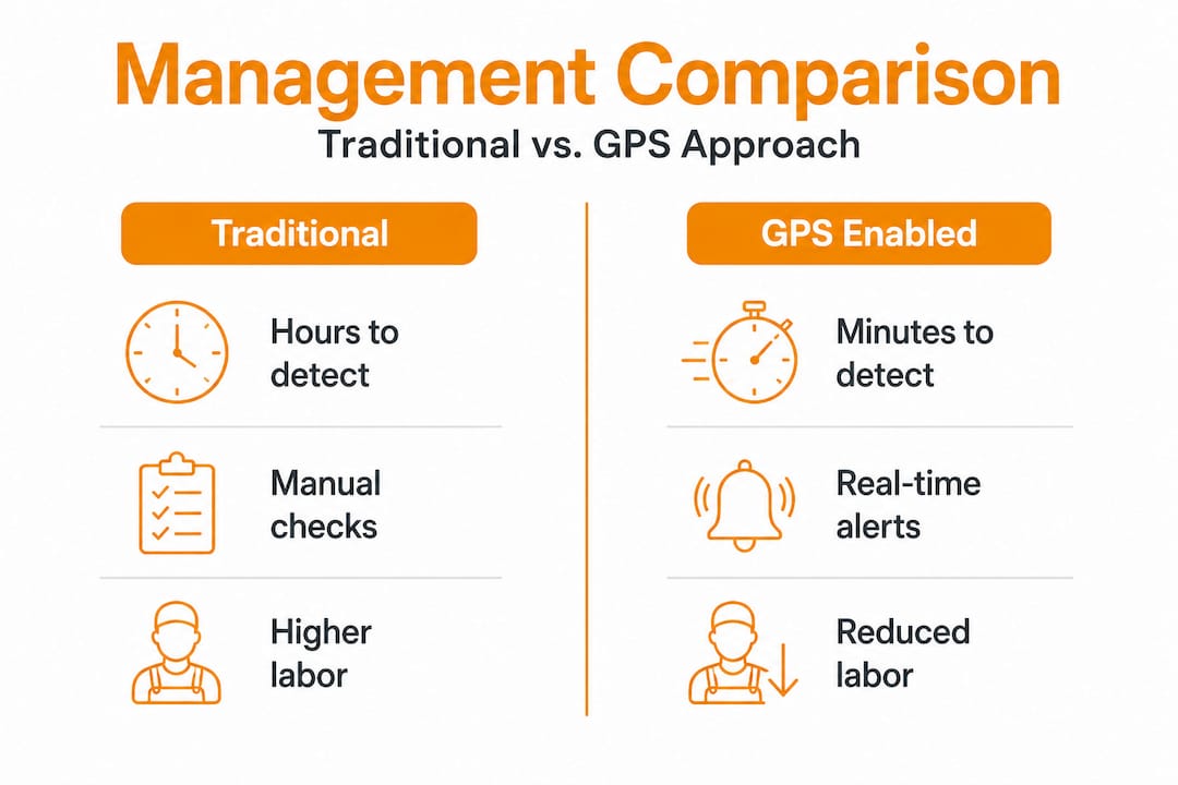
Traditional management vs. GPS-enabled management:
| Factor | Traditional management | GPS-enabled management |
|---|---|---|
| Escape detection | Hours to days | Minutes via alert |
| Breeding verification | Visual check only | Movement and proximity data |
| Pasture utilization | Estimated by eye | Heat map confirmed |
| Labor for daily checks | 2 to 4 hours daily | 15 to 30 minutes remotely |
| Predator detection | After the fact | Cluster alert in real time |
Labor savings alone justify the investment for many operations. Driving fence lines and counting cattle across large pastures can consume a full-time employee’s hours during peak season. GPS cuts that routine down dramatically, freeing your team to focus on higher-value tasks like animal health, infrastructure maintenance, and breeding management.
Pro Tip: Pull up your GPS history data any time a neighbor disputes a fence line crossing or a buyer questions your cattle’s grazing background. That timestamped location record is far more convincing than memory and can resolve disagreements in minutes rather than days.
Here is a practical sequence for getting the most out of GPS benefits once you have the system running:
- Set geofence boundaries around every pasture block before turning cattle out
- Configure alert thresholds for boundary breaches, unusual clustering, and extended inactivity
- Review movement heat maps weekly to assess grazing distribution
- Use breeding proximity data to verify bull coverage across the herd
- Archive seasonal data to compare year-over-year pasture performance
Financial considerations: Costs, ROI, and scalability
After appreciating the tangible benefits, it is crucial to understand the financial side of adopting GPS tracking. The upfront cost picture varies widely depending on the system you choose, the number of animals you are tagging, and whether you need satellite or cellular connectivity.
Typical GPS livestock tracking cost ranges:
| Cost category | Low end | High end |
|---|---|---|
| GPS ear tag or collar (per unit) | $150 CAD | $600 CAD |
| Annual subscription (per unit) | $50 CAD | $200 CAD |
| Base station or gateway | $500 CAD | $2,500 CAD |
| Setup and integration | $0 (DIY) | $1,500 CAD |
For a 100-head cow-calf operation, you might spend $20,000 to $30,000 upfront to tag every animal, which sounds steep until you calculate what a single season of escaped cattle, emergency vet calls, and neighbor disputes actually costs you. For most mid-sized operations, the break-even point falls somewhere between two and four years.
The ROI case is strongest for remote pastures. GPS tracking pays off for pastures over 50km from home, where bulls staying with the herd consistently sired more calves, with individual bulls recording between 6 and 38 calves per season depending on management. When you factor in the value of a single calf at current market prices, even modest improvements in breeding efficiency cover a significant portion of your technology investment.
“The technology is reliable through Canadian winters, but connectivity gaps and terrain challenges in certain regions remain real obstacles that producers need to plan for before committing to any single system.” — Performance and reliability of GPS tracking in livestock systems
That quote reflects a balanced view of the technology. High upfront costs are a genuine barrier, especially for smaller operations running under 50 head. But the long-term savings from reduced labor, fewer lost animals, and better breeding outcomes tip the scale for most producers who run cattle on large or remote pastures. Understanding virtual fencing costs alongside GPS tracking expenses gives you a fuller picture of what a modern, technology-enabled operation actually looks like financially.
Here is how to think through the ROI calculation for your own operation:
- Estimate your current annual cost of escaped cattle, including labor, vet bills, and lost animals
- Add the labor hours spent on daily checks and multiply by your hourly cost
- Calculate the value of one additional calf per bull per season at current market price
- Subtract those combined savings from your total GPS investment cost
- Divide the net cost by annual savings to find your break-even year
Key challenges and practical adoption tips
With costs, savings, and benefits in mind, what practical hurdles and implementation tips should you know before taking the plunge? Canadian conditions are not gentle on electronics, and GPS livestock tracking is no exception.
Extreme cold below -15°C reduces battery life and can affect tag reliability, which is a serious concern for winter calving operations or ranchers who leave cattle on range through late fall. Solar-powered systems like the Gallagher eShepherd neckbands help offset this by recharging during daylight hours, but short winter days in northern latitudes reduce that advantage. Battery management and recharging schedules need to be part of your adoption plan from day one.
Connectivity and terrain challenges are real in many parts of Canada, particularly in foothills, boreal fringe, and areas where cellular networks thin out. Satellite-based systems solve the coverage problem but add cost and sometimes reduce update frequency. Knowing your carrier coverage map before you buy is not optional, it is essential.
Common challenges and how to address them:
- Cold weather battery drain: Choose solar-assisted or high-capacity battery units; schedule recharging windows in your fall management calendar
- Connectivity gaps: Map your pastures against carrier coverage before selecting a system; consider satellite options for remote blocks
- Learning curve on data platforms: Invest time in training before turnout season, not during it
- Animal acceptance: Introduce collars or ear tags during handling to minimize stress
- Physical fence dependency: GPS does not replace wire; maintain your physical boundaries as a primary containment system
That last point deserves emphasis. GPS supplements but does not replace physical fencing, and treating it as a complete substitute is a mistake that will cost you animals and credibility with neighbors. Understanding how virtual fencing works alongside GPS helps clarify what each technology actually does and where the boundaries of each system lie. Real-world virtual fencing case studies from Canadian operations show how producers are layering these tools intelligently rather than replacing one with another.
Pro Tip: Start with a pilot project on a single group of 20 to 30 animals for one full grazing season before committing to a whole-herd rollout. That trial gives you real data on battery performance, connectivity reliability, and actual labor savings in your specific conditions, which is worth far more than any sales brochure.
A fresh perspective: Why GPS tracking is more than a high-tech add-on
Now, let’s step back and consider the bigger picture, drawing on hard-won lessons from the field. The conventional wisdom in Canadian agriculture has long treated technology adoption as a luxury reserved for large corporate operations or early adopters with money to burn. That framing is wrong, and it is costing mid-sized family operations real money every single year.
The ranchers who are quietly pulling ahead of their neighbors are not necessarily the biggest or the best-funded. They are the ones who recognized early that labor shortages, predation pressure, and climate variability are not temporary inconveniences but permanent features of the landscape they operate in. GPS tracking does not just tell you where your cattle are. It builds a layer of operational resilience that traditional management simply cannot match when you are short a hired hand, dealing with a wolf pack moving through, or trying to prove your grazing management to a government auditor.
There is also a future-proofing argument that rarely gets made clearly enough. The next generation of smart fencing and grazing systems, including virtual fencing, automated water management, and AI-driven health monitoring, all depend on the same data infrastructure that GPS tracking builds today. Ranchers who are already comfortable reading movement data and acting on alerts will integrate those next-generation tools far faster and more effectively than those starting from scratch. Investing in GPS now is not just about solving today’s problems. It is about building the data literacy and operational habits that will define competitive ranching in the next decade. Solid rotational grazing fence insights show how physical and digital systems work together to create more productive, sustainable operations.
The uncomfortable truth is that waiting for the technology to get cheaper or easier is a strategy that keeps paying costs you cannot see on a spreadsheet: the bull that wandered off during breeding season, the cattle that spent three weeks in the wrong pasture, the hired man you cannot replace. GPS tracking makes those invisible losses visible, and that visibility is where the real value lives.
Ready to get started with GPS livestock tracking?
For ranchers who see the value, here’s how to take the next step toward smarter, safer herds.
FenceFast has spent 26 years helping Canadian producers find the right combination of fencing, virtual fencing, and animal management technology for their specific conditions. Whether you are looking at your first GPS pilot project or planning a full-herd rollout across remote pastures, the team at FenceFast can walk you through system selection, connectivity planning, and available government funding programs like OFCAF and BMP grants that can offset your upfront costs significantly.
From Gallagher eShepherd virtual fencing neckbands to base stations and app-based herd management tools, the product catalog is built around what actually works in Canadian conditions. Get in touch for a custom quote, ask about pilot project setup guidance, or browse the full selection of GPS-enabled livestock tracking solutions designed for operations just like yours.
Frequently asked questions
Do GPS livestock tags work in extreme Canadian winter conditions?
Most GPS tags are engineered for Canadian winters, but cold below -15°C reduces battery life and can affect reliability, so choosing solar-assisted units and planning recharging schedules is essential for year-round use.
Does GPS tracking replace the need for physical fences?
No. GPS supplements physical fencing but cannot fully replace it; maintaining secure physical boundaries remains a non-negotiable part of responsible livestock management.
What is the return on investment for GPS livestock tracking?
ROI is strongest for operations with remote pastures over 50km from the home quarter, where labor savings, reduced escapes, and improved breeding outcomes typically deliver break-even results within two to four years.
How can GPS tracking improve herd health and breeding?
GPS improves bull fertility tracking by confirming which cows are being covered and flagging unusual movement patterns early, allowing producers to intervene before health or breeding problems escalate into costly losses.
Recommended
- RFID in animal management: boost livestock efficiency – FenceFast Ltd.
- RFID for Animal Tracking: Efficient Solutions for 2025 – FenceFast Ltd.
- What is virtual fencing for cattle? Herd control explained – FenceFast Ltd.
- Portable fencing advantages for Canadian farms: boost efficiency – FenceFast Ltd.

